
In-Depth Proprietary Technology
Spatially Adaptive Multiple Attenuation (SAMA)
There exist a wide breadth of seismic multiple removal techniques used throughout the seismic processing industry, including moveout-based demultiples (e.g. Radon) and predict-and-subtract multiple attenuation (e.g. 3D SRME).
Predict-and-subtract techniques construct a multiple model based on similarity to existing seismic structures. Because the modelled multiples are extremely similar to true signal, careful and conservative least-squares subtraction is required to ensure that primary signals are not removed or attenuated. As a result, these demultiple approaches are often unable to fully remove multiples without damaging primary signal.
In-Depth’s latest demultiple technology, Spatially Adaptive Multiple Attenuation (SAMA), improves upon pre-existing predict-and-subtract methods by adding two additional layers of adaptive multiple modeling prior to least-squares subtraction. First, a least-squares matching step allows for the joint modeling of several multiple generators simultaneously, improving their accuracy and power. Next, an automated spatially-adaptive filter is placed on the joint model before subtraction, allowing the demultiple to subtract gently in regions with significant primary signal and harshly in regions where primaries are likely to be unaffected.
This means In-Depth’s new SAMA technique produces a cleaner result with fewer remaining multiples while protecting key primary reflectors. Our 2024 publication with Chesapeake Energy (now Expand Energy) illustrates the power of this technique on data in the Haynesville Shale, Louisiana. (Fig. 1)
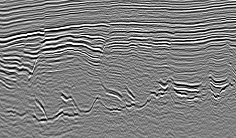
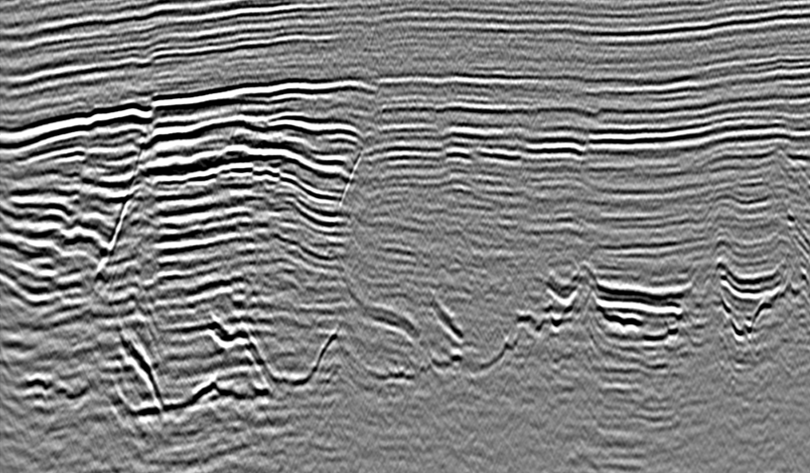
Fig. 1. Before (left) and after (right) Spatially-Adaptive Multiple Attenuation (SAMA) applied to land data in the Haynesville Shale. SAMA is able to strongly attenuate interbed multiples while minimizing harm to primary reflectors, even in complex regions with overlapping multiples and geology. Results published in partnership with Chesapeake Energy (now Expand).
Joel Latchman, Rika Burr, Jonathan Woolley, Anna Nolan, Bin Gong, Jinming Zhu, and Fang Yuan, “Interbed multiple attenuation with an automatic spatially adaptive thresholding operator: a case study in the North Louisiana Salt Basin”, SEG Technical Program Expanded Abstracts 2024.
Fig. 2. Picked multiple-generating horizon (blue line) and corresponding 2D horizon amplitude map. Using several of these horizons, we generate a joint, least-squares matched multiple model we use to perform spatially-adaptive multiple subtraction. The extracted horizon amplitudes are used in both multiple model generation and in the spatially-adaptive filter applied before least-squares subtraction.
Fig. 3. Joint least-squares matched multiple model produced from several multiple-generating reflector horizons. These predicted multiples are weighted using an automated spatially-adaptive filter designed to prevent primary signal attenuation while maximizing removed multiples. This filter incorporates extracted multiple-generator horizon amplitudes as well as other geological information to minimize primary leakage.